Earth observation imaging: a breakthrough in insurance risk
Managing risk in an ever-changing world is becoming increasingly challenging: the consequences of climate change will result in lasting – and in some cases irreversible – damage to the planet we live on. The impact of a warming world, such as the increased rate of extreme environmental events like flooding and wildfire, represents a volatile threat affecting property, food security, innumerable assets and, ultimately, human life.
These threats will occur on all scales, from the cliffside property that collapses due to increased coastal erosion to the failure of entire crops across hundreds of kilometres. They will also evolve with time, from the seasonal unpredictability of rainfall to long-term changes to the growing season. Almost every sector will be affected in some way.
How can we sustain our economy and protect society in the face of such a challenge? We must be agile to the threat and learn to adapt to a changing world. While our long-term strategy must always be to halt, or ideally reverse, anthropogenic climate change, we must accept the fact that the challenge is now, and we will have to learn to roll with the punches.
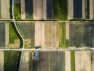
Using star-counting tech to estimate crops in a field
Francis Bacon once said ‘knowledge is power’. Although that sentiment is now trope, it is also incredibly relevant. Empirical knowledge is perhaps the most powerful asset for our understanding of risk, particularly when that risk is constantly changing. And when it comes to a global challenge, space offers a vantage point ideal for gathering exactly the data we need, allowing us to measure and map the entire planet down to scales of a metre or less.
Data from Earth observation satellites are being increasingly employed across multiple sectors to enable organisations to identify and understand trends, detect and map catastrophic events like flooding and drought, predict risks, and make faster, more informed decisions. Currently, there are over 1,000 Earth observation satellites in space feeding ‘remote sensing’ data back to us about the planet we live on. This number is growing rapidly.
As an astrophysicist, my focus has been on detecting and understanding the faintest signals from the furthest depths of the universe. I like to think of this as the ultimate remote sensing challenge, pushing data to its limit to gain meaning. But in recent years I have turned my attention to the analysis of Earth observation data – these satellites are essentially telescopes pointed down after all. My interest was sparked by a chance conversation with my oldest friend, a dairy farmer in Cornwall where I grew up. We were discussing how satellite data can be used by farmers to make quick work of assessing the health of their land. I realised that I could use some of the same skills and techniques in the analysis of astronomical data to Earth observation data. Instead of estimating the number of stars in a distant galaxy, I might be estimating the number of ears of corn in a field.
Eliminating interference from cloud cover
I soon came across a key problem, the achilles heel of Earth observation: cloud cover. When clouds block the view of the ground, intelligence is lost. This severely limits the effectiveness of satellite data, particularly where regular, reliable data is needed. So, I set about solving this problem with my PhD student, Mike Smith. It has led us to a patented algorithm using cutting edge deep learning ('AI') techniques. We launched Aspia Space, which provides clients with our ClearSky service, in early 2022.
ClearSky works by utilising a particular type of Earth observation data that is actually impervious to cloud cover: Synthetic Aperture Radar, or SAR. SAR is a technique that bounces radio waves off the surface of the Earth and then detects their reflectance back at the satellite. The downside is that this data is challenging to interpret. We developed a method to translate SAR imagery to visible-light images of the kind acquired by more traditional Earth observation satellites. Because we are using SAR as the input, these images are cloud-free.
A recent report from Allianz found that natural disasters pose the third greatest business risk to organisatons in 2022, with climate change ranked in the top six greatest global threats to organisations this year. From farmland in the US corn belt to flood plains in Asia, we now have the ability to predict detailed hyperspectral satellite imagery of the ground, even in the presence of 100% cloud cover. Our technology can, on a rolling basis, generate cloud-free hyperspectral satellite imagery anywhere in the world, to a fine resolution of about 10 metres. This intelligence forms the basis of data products that relate to the properties of the Earth’s surface, from the health of crops to the presence of snow and surface water. Importantly, because this data stream is uninterrupted by (potentially long) periods of cloud cover, we can reliably measure how these properties are changing with time, from days to months to years.
Future scope for the insurance industry
Imagine being able to rapidly identify and map crops under stress due to drought, detect the presence of surface water due to flooding, or measure trends in yield due to unfavourable growing conditions. This information allows our customers to react faster to minimise loss, to boost performance or even pre-empt and therefore mitigate deleterious events. Perhaps more importantly, we can apply this methodology to an entire multi-year and growing archive of data to quantify the likelihood that various hazards occur, pinpointed to location. As more data becomes available day-by-day, we can continuously re-evaluate the risk profile as it responds to the dynamic climate.
Following our successful launch in the UK in partnership with Origin Digital, which enables sustainable food production through the use of satellite imagery in precision farming, Aspia Space is now focused on developing our offering for insurers, financial services and other sectors. We’ve recently joined the prestigious NVIDIA Inception programme, designed to nurture startups revolutionising industries with advances in AI and data sciences. This is allowing us to significantly scale up, not only in the application of ClearSky to larger and larger areas of the globe, but also in the application of our unique knowledge and knowhow to extract the maximum amount of meaning from this data. We aim to provide new insights to more markets and industry sectors, as well as develop new products at the interface of AI and Earth observation. Our mission is that cloud-free satellite imaging will enable many more organisations to make better decisions, improve sustainability, and better manage risk in a changing world.
About the author: Professor Jim Geach is founder of Aspia Space and Professor of Astrophysics at the Centre for Astrophysics Research, University of Hertfordshire. His research has focused on understanding the formation and evolution of galaxies in the distant universe, but in recent years he has turned his attention to the application of astrophysical data analysis techniques to satellite imaging of the ground.